

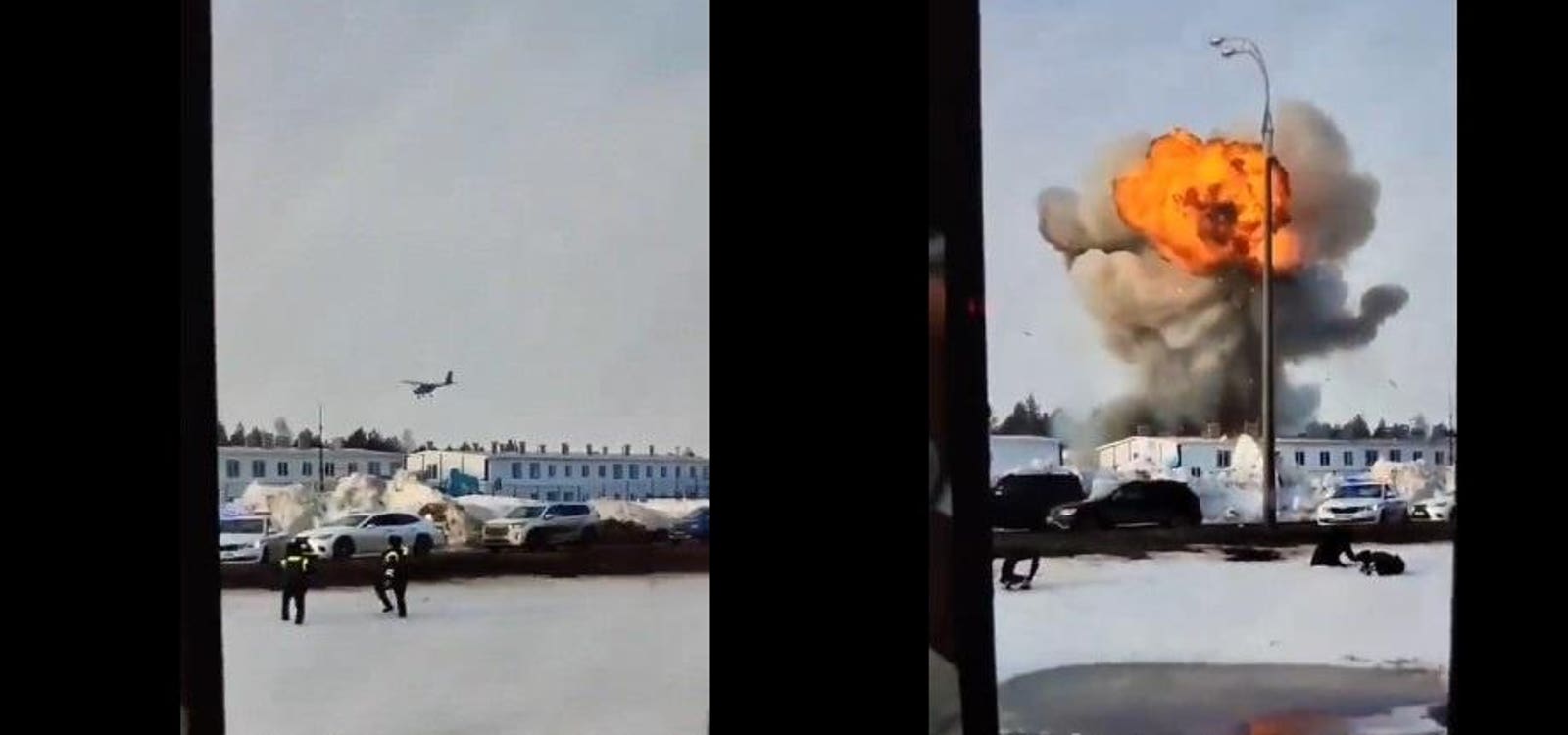
In a sharp escalation of its drone campaign targeting strategic industries deep inside Russia, Ukraine seems to have fitted Cessna-style light planes with remote controls, packed them with explosives and flown at least one of them more than 600 miles to strike a Russian factory in Yelabuga, 550 miles east of Moscow.
Ironically, the Russian factory produces—you guessed it—drones.
Russians on the ground recorded the shocking scene as the light plane dove onto the sprawling Alabuga Special Economic Zone industrial campus, where workers assemble Iranian-designed Shahed drones that, just like Ukraine’s DIY Cessna-style drone, can range as far 600 miles with an explosive payload.
“dead reckoning” is the technical term for precalculated navigation, adjusting the path only from sensors like IMUs
(unless they used stuff like cameras and POI based navigation, but that seems unlikely)
I don’t think it’s correct to say normal planes use IMU more than GPS, they’re all complementary. GPS tells the general direction and the IMU helps keeping the plane stable (no sudden jerks to turn when the GPS drifts). And ground radar tells the plane when it’s too far off the path.
“Dead reckoning” as in “dead reckoning” as in “deduced reckoning”. It’s the same kind of navigating people have done on boats for millennia. You start from a known point and move in a specific direction at a known speed for a specific amount of time. Then you change your speed and/or direction for another specific amount of time. And so on. If you have the ability to do so then you update your known position along the way via known landmarks you might pass.
Yeah but the errors creep up, so if you don’t see the islands of hope after sailing for 18 days at speed x, you’re fucked :-)
That’s why you have several systems, like gps to periodically try to get a good signal, or manual override.
An alternative is terrain mapping. You look at the terrain bellow you and compare in a database. Tomahawks navigate that way.
That navigation system was originally designed for the US nuclear powered doomsday cruise missile which would have zoomed across the USSR at supersonic speeds, low altitude, spewing radiation as it goes and dropping the occasional nuke. It could have done this for days.
Given what they’ve done elsewhere I wouldn’t be surprised if it was 100% remote-piloted via satellite internet (most of their sea drones are controlled via Starlink, for instance) but in the case of fixed infrastructure, a smart fusion of GPS, IMU, and potentially video image matching for terminal guidance (these aren’t big bombs in the grand scheme of things and it’s important to hit the right part of a sprawling refinery or factory complex in order to knock it out for an appreciable amount of time) could overcome GPS jamming, and be well within the technical capabilities of the Ukrainian arms industry. TERCOM as implemented in the Tomahawk runs on early-80’s computing power, and it’s only gotten easier. Machine vision frameworks are widely available and well-understood software these days, and can run on fairly modest hobby hardware to boot.